If you are new to Melbourne there is something you need to know – the route 59 tram to Airport West doesn’t actually go to the airport! So why the confusing name?

The Yarra Trams website calls out the fact.
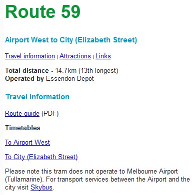
Route 59 begins outside Flinders Street Station, then heads north-west through North Melbourne, Moonee Ponds, Essendon and Keilor, until it finally arrives at the Airport West terminus.

Where Airport West is the name of the suburb – given because the location west of Essendon Airport. Melbourne Airport is five kilometres further north-west from the tram terminus.
Footnote
Today route 59 just passes by Essendon Airport, but until 1976 it actually ran along Vaughan Street to the passenger terminal. Some photos from that time:
- Tram VR 53 poses on Matthews Avenue as Ansett Boeing 727 on final approach passes overhead
- Trams on an enthusiast tour shunt at the Essendon Airport terminus
- Tram W2 370 at the old Essendon Aerodrome terminus
- Track and overhead wire removed along Vaughan Street, following the commissioning of the new terminus on Matthews Avenue
- Trams pass on Matthews Avenue following the closure of the Vaughan Street tracks

Note 1:
When the freeway was built around Essendon Airport, a bridge over it was constructed to join English Street with Matthews Avenue, right where those tram tracks used to turn into English Street.
That bridge is about to be demolished, and rebuilt to allow four freeway lanes each way under it.
(Originally it was two lanes plus an emergency lane, then the emergency lane was converted to a traffic lane in the last lot of road widening.)
Note 2:
Melrose Drive was originally wide enough to run a tram line all the way from Airport West out to Tullamarine Airport.
Some bright spark had an idea to sell half of it off for housing, so now it’s too narrow from Catherine Ave to Tadston Drive to ever run the tram through there.
Interesting find on Melrose Drive – it’s quite visible via Google satellite view:
https://www.google.com.au/maps/place/Melrose+Dr,+Tullamarine+VIC+3043/@-37.6970002,144.8761963,756m/data=!3m1!1e3!4m5!3m4!1s0x6ad6597d995b6385:0xf74c7847ff19e447!8m2!3d-37.6971864!4d144.8782459
Yep, if you zoom in on this route (from the present terminus, out to just near the new Esendon FC training ground)
https://goo.gl/maps/5MMHRzvxv312
you can see there is plenty of room to run a tram, EXCEPT for this 300 metre section: https://goo.gl/maps/ExNkonvADWm
You have to suspect that some vested interest got onto council and made sure that bit got sold off…
Interestingly, there’s no mention of or link to the convenient and cheaper option of the 901 Smartbus to Melbourne Airport from Broadmeadows station. This option to the Airport is poorly publicised and under utilised.
PTV don’t shout it from the rooftops, but the suburban bus routes that serve the airport are listed on their ‘Airport buses’ page:
https://www.ptv.vic.gov.au/getting-around/airport-buses/
Wonder why it was kept beyond Keilor Road at all – to serve workers at essendon airport who already used (and now had to walk a bit) and the industrial area where it terminates? Be interesting to know how popular it is at the terminus.
Alternatively, why wasn’t it extended those few miles to serve Tullamarine?
The answer is I suspect that there wasn’t a lot of support for trams generally – it was only the year before that the first new trams for decades started service, and it was to be another 10 years before any lines were extended (burwood highway mid 80s amiright?)
I was always fascinated by the tram next to freeway whenever we went to the airport (Tullamarine) as a teen – the wire supports were shorter and stripy painted, so planes didn’t crash into them I suppose.
Rohan, it terminates right outside Airport West Shopping centre.
Admittedly, it was much smaller when the terminus was built, as it opened the same year the terminus was moved (1976), but was enlarged in 1982 and again in 1999.
https://en.wikipedia.org/wiki/Westfield_Airport_West
Following the closure of the Essendon Airport stub, route 59 terminated at Matthews Avenue and Hawker Street – the extension to the shopping centre didn’t occur until 1992:
http://www.yarratrams.com.au/about-us/our-history/tramway-milestones/towards-the-modern-era/
Thanks Marcus.
I remember that now, it happened soon after I moved into the area.
I wonder if Westfield pressured them into the extension 🙂
Rohan, most of the area to the west of the tram line along Matthew Ave forms the residential Airport West suburb, a very healthy catchment.
The 501 bus in the area takes the roundabout way to Essendon through Strathmore Heights. And if you catch the 501 bus the other way you need to find a connecting service at Niddrie to travel further, hence many find it easier just walk to the frequent tram.
Just wanted to add, to all those people who believe we need a train line to the airport. During peak time, there is a bus which runs as often as every 13 minutes, takes around 15 minutes to get to Broadmeadows Railway Station, before eventually ending it’s long journey hours later in Frankston. During offpeak, it’s around every 20 – 30 minutes. During the week, there is literally only about 5 – 6 hours it doesn’t run.
Why do we need a train to the airport? In Sydney, if you get off at the airport, you lose like $10 during the process. That line also continues on and serves the wider community. A dedicated train service to the airport is a complete waste of time, especially for Melbourne. The area around the airport is already well served with public transport. We also now have Uber, which is half price a taxi fare.
The airport bus options go from many different areas around the city, not just from the city. So, a train to the airport, will simply just leave passengers stranded in the city.
If you were to do anything, I would spend the money you would have spent on a train line, on upgrading the Broadmeadows area, similar to what they did to Dandenong, and gentrify the suburb. Create a better bus interchange with the station.
Public transport runs at a loss, we need to create solutions that don’t make that worse. Last time I was in Sydney, 5 or so people got on the airport train for the city. That was money well spent. Not!
With Tullamarine Airport being a bigger transport hub than even Southern Cross station, a rail link to the city will be used. If you ever look at how many people use SkyBus, you’ll see that a train link will easily be a success if it didn’t cost as much.
Also, the Airport Link in Sydney is privately owned, hence the ridiculous price to use it.
The private sector doesn’t have a monopoly on high fares. Toronto’s Union Pearson Express is government run and had ridiculously high fares – until it was decided to cut them in half in order to attract patrons:
https://www.thestar.com/news/gta/2016/02/23/upx-to-slash-fare-by-more-than-half.html
The former Essendon Airport tram terminus went along the southern side of Vaughan Street, a little further north of English Street crossing on the level what was then ‘Lancefield Road’. It was extended on its own reservation on ballast during WWII in a similar way the lines around Maribyrnong were done to serve the munitions factories at a time of fuel rationing – the projects subsidised by the Commonwealth Government as part of the war effort. Essendon served as a maintenance hub for military aircraft which was the ultimate reason for the similarly-funded tram extension.
The changes can be seen on the over-watermarked Melway pages from The University of Melbourne. The old arrangement still there in 1976 with the section of Lancefield Road the only bit not freeway standard – the freeway to the north was built in the late 60’s with that to the south opened in the early 70’s:
https://digitised-collections.unimelb.edu.au/bitstream/handle/11343/23958/301396_UDS2013221-3-0025-wm.jpg?sequence=25
1977 sees it cut off with a new terminus built. Aerials will show the new track concrete embedded with the original on ballast, as per the last link in the main article above:
https://digitised-collections.unimelb.edu.au/bitstream/handle/11343/23959/301713_UDS2013221-4-0025-wm.jpg?sequence=25
1979 sees the bridge built and it nearing completion
https://digitised-collections.unimelb.edu.au/bitstream/handle/11343/23962/304128_UDS2013221-6-0027-wm.jpg?sequence=27
As noted above the bridge only allowed two lanes plus a shoulder each way, later made into three lanes each way. A fourth currently under construction requiring complete demolition and reconstruction.
Thanks for the Melway links Andrew – I’d forgotten about the University of Melbourne collection found online.
Don’t forget you can also see a clean copy of Issue 1 from 1966 on the Melway website.
Here’s page 16: http://melwayed1.melway.com.au/016.jpg
which also shows the tram running up Vaughan Street.
and now I know the tram went up Vaughan Street, not English Street, the background buildings make sense.
There’s no Google street view inside Essendon Airport yet, so I stopped in to take some current photos tonight. You can see that Vaughan Street has totally changed, but the hangars in the background are still there.
http://leslie-special.info/eap/
Thanks for sharing those ‘then and now’ photos. 🙂