This is the story of the Raleigh Road bridge over the Maribyrnong River, and the separate road and tramway bridges that once existed on the site.
Going back in time
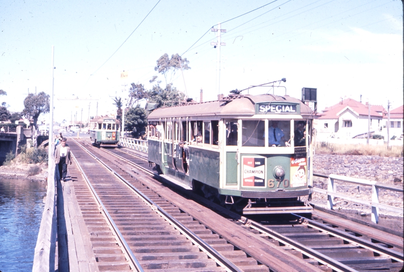
Today’s Raleigh Road bridge carries four lanes of traffic into the western Melbourne suburb of Maribyrnong.

Lining up with Maribyrnong Road in Ascot Vale.

And used by route 57 trams to West Maribyrnong and route 82 trams to Footscray.

But the bridge didn’t always carry cars – the 1966 Melway shows that road vehicles once had their own bridge to the north.

Taking a dogleg beside the Anglers Tavern, while trams had their own timber trestle bridge.

1945 Department of Lands and Survey photo map
So how did it come to be?
Early years
The first river crossing on the site opened in 1852 – a punt operated by Joseph Raleigh, owner of a nearby meat preserving works, to serve diggers headed to the goldfields. In 1858 the punt was replaced by a pontoon bridge.

The bridge was soon joined by two hotels – a two story bluestone building called the Raleigh’s Punt Hotel in 1866, followed by the the Anglers Hotel in 1870.

Charles Nettleton photo, SLV H82.246/2
And in 1870 the pontoon bridge was replaced by a sturdier timber bridge, funded by the nearby Melbourne Meat Preserving Works, and local landowner George Petty.

Charles Nettleton photo, SLV H84.79/1
Regular floods on the Maribyrnong River threatened the bridge.

Which needed to be patched up to cater for heavier traffic.

But it took until 1906 for work to start on a replacement. Designed by John Monash with five reinforced concrete spans, each nominally 40 feet (12.2m) in length, work started in 1909 and was completed in 1911.

In the years that followed, local residents agitated for the extension of trams from Ascot Vale into Maribyrnong.
But it took the outbreak of World War II for the tram extension to be approved, to serve the explosives factories on the western side of the Maribyrnong.

As might be expected for wartime, the minimum effort was made – the existing road bridge was left in place, trams being carried over the river by a timber trestle bridge.
A fatal fall
In November 1950 a man walking across the tramway bridge fell and drowned.

The bridge being a popular shortcut for local residents.
Schoolboys Use Bridge As Short-Cut
The Maribyrnong tramway bridge was perfectly safe for pedestrians, the publicity officer of the Melbourne and Metropolitan Tram ways Board, Mr L. E. Russell, said today.
Last night, Edward Kordus, a New Australian, of Raleigh Street, Maribyrnong, was drowned when he slipped into the river from the bridge.
“Hundreds of people pass over the bridge every day,” Mr Russell said. “This is the first fatal accident that I have heard of.”
Today, a Herald reporter and photographer inspected the bridge.
It has three wooden gangways for pedestrians. They are about 2ft. 3in. wide and. are bolted to the tram line sleepers. There is a clear drop through
a two- foot gap, between the sleepers, to the water below.It would be possible, but unlikely, for a man to slip through. The bridge is lit at night.
Is Short Cut
The reporter saw half-a-dozen people pass unconcernedly over the bridge. They included a small boy who said that he and his schoolmates used the bridge as a short-cut to school.
Pedestrians cut off about 100 yards by using this bridge instead of a neighbouring one, which is for motorists and has only one footpath.
The bridge has notices “Trams Only,” but this is meant to apply only to cars. The gangways were put across the bridge expressly for pedestrians.
But some locals didn’t consider the bridge safe for pedestrians.
I cannot agree with the Tramways Board Publicity Officer that the Maribyrnong River Tramway Bridge is safe for pedestrians. If it were, the board would surely have provided a more convenient approach than by the open cattle pits at the north-east end. It should be stressed that the bridge was erected as a temporary structure during the war and should now be replaced.
New warning signs were soon added.
The tramway bridge over the river at Maribyrnong is often used by pedestrian traffic but this practice is extremely dangerous. Before Christmas a
New Australian fell through the bridge and was drowned and recently another fatality was only narrowly averted.Notices are posted on the bridge warning people that they must not walk across or use the bridge for swimming but at Monday’s council meeting, Cr. J. McDonald declared that this hadn’t stopped the practice.
He moved that the Tramways Board be asked to prosecute any persons contravening the by-laws.
But the Braybrook Council wanted the bridge replaced.
The necessity to do something about the Tramway bridge over the river at Maribyrnong was mentioned again in the Braybrook Council on Monday.
Though the bridge is purely for trams it is used a lot by pedestrians and last week a New Australian walking along fell through the bridge and was drowned in the river.
Cr. J. McDonald said that the traffic bridge alongside was almost as dangerous.
The Council only recently gave consideration to’ improving the bridge and has been in contact with several government departments who are interested parties.
It was decided to ask the authorities to expedite the reply to the Council’s proposition.
Cr. Dobson said that residents of the area should be told that the Council had been active over the matter.
And the new bridge
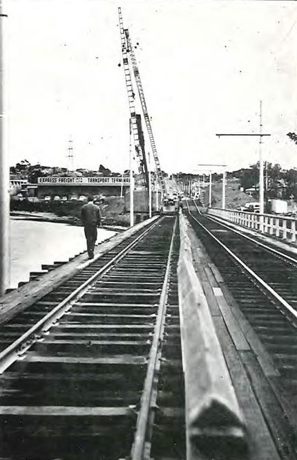
In the years that followed the tramway and road bridges continued to deteriorate, but it took until the 1960s for work to start on a replacement – a seven span bridge 145 metres (478 feet) long, carrying a roadway 15 metres (50 feet) between kerbs with two 2 metre (7 feet) footpaths.
The first stage being ground stabilisation for the western abutment.

Country Roads Board annual report 1965
Followed by a complicated juggling act.

A.E. Smith photo, SLV H83156/49
Equipment set up on one track.
Country Roads Board annual report 1967
While the foundations for the new bridge were driven.

Country Roads Board annual report 1967
The new piers were built alongside the existing timber trestle.

A.E. Smith photo, SLV H83156/47
While trams continued to use it.

A.E. Smith photo, SLV H83156/51
The Country Roads Board describing the process in their 1967 annual report.
The 1964/65 and 1965/66 Annual Reports described the methods adopted to accelerate the consolidation of the compressible strata at the Sunshine abutment. This report refers to the construction procedures used, in view of tram traffic requirements and the confined space for pile driving.
The new bridge is on the same alignment as the original timber and steel girder tramway bridge. Stage construction methods have been used as described below, to maintain the two-way tram service while this bridge is under construction. Road traffic has continued to use the existing road bridge.
Stage 1
Step 1. The tram traffic was restricted to the existing upstream track while the pier pile groups at the downstream side of the new bridge were driven.
Step 2. The tram traffic was restricted to the existing downstream track while the pier pile groups on the upstream side of the new bridge were driven. The downstream pile caps and columns were constructed during this stage.
Step 3. The tram traffic was restricted to the existing upstream track, ,and the downstream track and the downstream section of the superstructure were demolished. The abutment piles were driven and then the pier and abutment crossheads and the superstructure for the downstream side of the new bridge were constructed.
Step 4. The tram traffic was restricted to a temporary single track located on the Stage 1 deck of the new bridge.
Stage 2
Step 1. The upstream superstructure was demolished and the abutment piles beneath the upstream track were driven and the upstream crossheads and superstructure completed.
Step 2. The tram tracks were located at the final position on the structure.
Step 3. Tram traffic was permitted on the final location two way, double track.
The two stages of the superstructure are separated by a longitudinal joint running the full length of the bridge.
And the design of the foundations.
The bridge foundations consist of concrete filled 18 inches diameter steel shell piles up to 70 feet long in the abutments and up to 60 feet long in the piers. At some of the pile groups it was necessary to use a special pile toe incorporating an RSJ to penetrate hard layers above the contract level and to achieve the required degree of fixity. The pile driving was done with a B.S.P. diesel hammer on hanging leaders supported from Dutch shear legs. This type of pile driving frame was very suitable for this site where working space was extremely confined.
Once the new bridge was completed, the 1911 concrete bridge by John Monash was demolished.

Country Roads Board annual report 1967
Giving the scene seen today.
Footnote: another upgrade
Now pedestrian and cyclist traffic is overwhelming the current bridge, so $2.7 million is being spent to widen the paths on each side of the bridge.
The Raleigh Road Bridge shared user path and surrounding trails are popular routes for cyclists and pedestrians.
The Victorian Government is investing $2.7 million to provide new three-metre-wide paths on each side of the Raleigh Road Bridge.
With over 33,000 vehicles and 3,000 pedestrians and cyclists each day, the Raleigh Road bridge upgrade will provide a safer experience for locals and drivers alike.
The shared user path upgrade will provide safer active transport infrastructure by:
- Providing a safer crossing for cyclists and pedestrians on the Raleigh Road Bridge through increasing the path width to 3.0m on both sides
- Improving connections to the river trails to the north and south of the bridge
- Relocate tram poles to remove fixed hazards
- Upgrades to the bridge barriers.
We’re starting works in November 2020 and expect to complete construction by early 2021.
Sources
- Country Roads Board annual report 1967
- The Herald, 10 November 1950
- Maribyrnong Heritage Review – Volume 2: Environmental History
- Living Museum of the West – Ecomuseum Broadsheet: Getting Around
- Victorian Places: Maribyrnong
- Timeline of the bridge rebuilding
And a few more photos
- X2 class tram No 678 heads across the old bridge in 1962
- Looking towards and along the old bridge.
- ‘Bathing and diving prohibited’ sign on the old bridge.
- Looking south-west and north-east over the bridge replacement works.
- Single track over the bridge and with one track gone during the works.
Postscript: Melbourne’s other tram bridges
After putting this post together, I realised there were a few more tramway only bridges in Melbourne.

The Miller Street’ hump next to Preston Workshops connects St Georges Road to High Street.

The tangle of bridges at St Kilda Junction.

And one carrying the route 59 tracks over the Calder Freeway at Airport West.


There are also tram only bridges on the Port Melbourne and St.Kilda light rails, being a former train line.
Also a bit hidden, but there are tram only bridges in St.George Road over the water mains at either end of the split tram track section. They are hidden because either side of them is filled in with dirt and grass.
I’d forgotten about the light rail routes, but the St. Georges Road ones are an curious setup.
“And in 1970 the pontoon bridge”. 1870?
Fixed!
Confusing 1800s for the 1900s seems to be a common brain fart for me – just goes to show the period of time I usually focus on. 😛
The duplication of the tramway bridge occurred fairly quickly, I believe. Possibly 1943, presumably there was lots of munitions worker traffic.
Building the tram extension before the war might also have been smart.
Trams really dominated the area, with the majority of military factory workers commuting by tram and cars weren’t popular. What the factory products did being a different issue, it was a good example of efficient tram usage.
No surprise that cars saw little use – it was the middle of World War 2, Australia was reliant on imported petrol, and rationing was in force.
https://www.awm.gov.au/articles/journal/j36/petrol
So it made sense for workers to go by trams powered by domestically generated electricity.
Apparently the boaties hate this bridge. I’m not a boatie, but most pylon bases run the same way as the flow of the water, or at 90 degrees; these are about 45, making the pathway between them very narrow and prone to a cross-current.
I heard the same story somewhere – possibly on a trip up the Maribyrnong River with Blackbird Cruises.
http://www.blackbirdcruises.com.au/
But for some reason I didn’t take any photos of said bridge on that trip. 🙁
Also there are below water remains of the old bridge that are a hazard to deeper draft boats
[…] on the site from 1849. A competing crossing was operated by Joseph Raleigh at Maribyrnong, which replaced his punt with a bridge in […]